


Explore Hundreds of Waterfalls in the Western U.P.
Beautiful Bond Falls
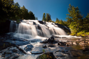
There are more than 150 waterfalls across this breathtaking area of the Upper Peninsula. In the Autumn, the waterfalls are framed by maple crimson and aspen gold. In the winter, they create strange ice formations. All are spectacles of white splendor that are sure to make any vacation memorable.
Downloadable Map of Waterfalls
The National Black River Scenic Byway
The National Black River Scenic Byway includes, Great Conglomerate Falls, Potawatomi, Gorge, Sandstone, and Rainbow Falls. As you visit our waterfalls, stop and take notice of the signs explaining the conglomerate rock formations.
Directions: From Hwy. US 2 in Bessemer take Powderhorn Rd North. When you come to the T in the road at the stop sign, make a left hand turn on Black River Rd. You will find all the waterfalls on this Road. This road is approximately 14 miles long, ending in the only Harbor & Marina operated by the USDA Forest Service in the lower 48 states.
Great Conglomerate Falls– This is a very large waterfall which is divided by a wide conglomerate rock formation. This waterfall is well marked. Walking trail 3/4 mile.
•Access: Improved Trail
•Walking Time: 15 min. – 45 min
•Vertical Drop: 20 ft. and Over
Potawatomi Falls– Potawatomi, which is barrier free (from Gorge Parking Lot), is one of the most beautiful waterfalls on the Black River. This waterfall is well marked. A restroom is available at this site. Walking trail is approximately 1/8 mile. Shares common road in with Gorge Falls and 2 separate parking lots.
•Access: Improved Trail
•Walking Time: 15 min. or Less
•Vertical Drop: 20 ft. and Over
Gorge Falls – This conglomerate canyon has a 34 foot drop. Potawatomi and Gorge Falls are accessible by the same parking area. Walking trail is approximately 1/8 mile.
•Access: Improved Trail
•Walking Time: 15 min. – 45 min
•Vertical Drop: 20 ft. and Over
Sandstone Falls – This waterfall meanders over rocks giving it a unique appearance. It is located on a beautiful spot on the Black River, with a well marked, short 1/4 mile walking trail.
•Access: Improved Trail
•Walking Time: 15 min. – 45 min
•Vertical Drop: 20 ft. and Over
Rainbow Falls – A Beautiful Waterfall that is extremely photogenic on the East part of the River. Enjoy the scenery on your 1/2 mile walk to the waterfall. Take is easy, there are many stairs.
•Access: Improved Trail
•Walking Time: 15 min. – 45 min
•Vertical Drop: 20 ft. and Over
Gabbro Falls/Bakers Falls
Located on the Black River, take US2 between Bessemer and Wakefield to Blackjack road. Turn north and go pas second gas line clearing and park, approx 1.5 miles. Walk the line west to river river. Upper and lower river locations.
Upper and Lower Gabbro/Bakers
•Access: Rough Trail
•Walking Time: 5 min. – 10 min
•Vertical Drop: 15ft. and Over
Montreal River
Interstate Falls – Take US2 west into Wisconsin, .6 miles after the Hwy 51 overpass. Turn right on gravel road. Pass the gravel pit on the right and go .4 miles where road turns right and a trail heads off to the left to Insterstate Falls .35 miles. Coming back from the falls stop about halfway back and listen for more falls. head toward the sound and see the Unamed Falls about 3.5 miles.
•Access: Rough Trail
•Walking Time: 15 min. – 45 min
•Vertical Drop: 20 ft. and Over
Unnamed Falls
•Access: Rough Trail
•Walking Time: 15 min. – 45 min
•Vertical Drop: 20 ft. and Over
Peterson Falls – Back at the car, continue down the road 50 yards. Where the gravel road crosses, turn left and park. Walk to end of the road and go right on trail. 15 miles.
•Access: Improved Trail
•Walking Time: 15 min. – 45 min
•Vertical Drop: 20 ft. and Over
Superior Falls
Located on the Montreal River. Take US2 west in Wisconsin to Hwy 122. Turn north and follow into Michigan. When you cross the river between WI and MI, take the first road to the left and park in the power company parking area. Follow the signs to view falls.
•Access: Improved trail
•Walking Time: 15 min. – 45 min
•Vertical Drop: 20 ft. and Over
WaterfallPDFOnlinecomplete.pdf
Powdermill Falls
Large waterfall that has a good amount of water falling into a large pool. This walk is short and easy.
Directions: From Hwy US 2 between Ironwood & Bessemer, go north on Powderhorn Road approximately two miles. You will see a sign for the Alpine Inn & Village. Just past that sign is a dirt road on you left and a dirt path on your right. Park you vehicle on the shoulder of the road and follow the path to the waterfalls.
Maple Creek
Just past the driveway to Potawatomi & Gorge waterfalls ( on the Black River National Forest Scenic Byway) is Maple Creek road on your left. Take the dirt road in about 4 miles to the bridge and find a parking spot. The falls are below the bridge and upstream. Downstream is Lake Superior about 1/2 mile.
Nelson Canyon Falls
Beautiful waterfall and a beautiful hike that ends with a spectacular climax. Approximately 45 minute walk that is not difficult. Take your time to enjoy and explore this area.
Directions: Three miles West of Lake Gogebic on Hwy 64 take C Camp Rd; cross Nelson Creek (culverts) and continue for almost one mile until you are on your way uphill there is a two track (path). Park and walk the two track in and as it peters out or turns right; walk angling left. When you get to the river walk downstream.